
Town of Pittsford Neighbor Sources
At a Town of Pittsford address, an adjacent parcel is the useful starting definition. It is a lot that touches the target parcel, not necessarily the household next door or everyone who lives nearby. The map establishes the geography. The property roll gives tax-parcel and assessment context. The deed index records title parties and dates. A voter lookup can confirm registration information for one known person, while a historical directory may show a dated name and address. None of these sources becomes a complete current block roster when read alone.
| Block source | What it can show about a block | Access |
|---|---|---|
| Mapping Monroe parcel map | Touching parcels, streets, parcel shapes, public layers, and owner/address report links | Public viewer; select each parcel separately |
| Assessment roll and property route | Tax parcel, assessment, exemption, and taxing-district evidence | County portal or Town Assessor verification |
| Monroe Clerk deed index | Recorded title parties, transaction chronology, and legal descriptions for each parcel | Free index, terminal, subscription image access, or copy request |
| Monroe voter lookup | Registration and polling context for one known nearby person | Individual inputs only; no public block browse |
| Pittsford directory collections | Historical listed occupants and businesses along a named street | Rochester Public Library's dated scans and collections |
| Community associations | Public identity, activities, and membership instructions where the group publishes them | Association site; member directories may be restricted |
A recorded owner might use a different mailing address, and a tax exemption is not a list of occupants. Treat the public records as distinct observations. This approach gives block context without making claims about a private household.
Map a Pittsford Neighbor Block
The documented adjacent-parcel workflow uses the Mapping Monroe parcel viewer. Its available tools include house number, house owner, Identify Polygon, Layers, Basemap, Reports, Print, Share, and Share Map. The viewer does not document a radius or buffer tool in the inspected source. Instead, select the target parcel, zoom until the touching polygons are visible, and identify them one at a time. Save a dated map view if a comparison may need to be repeated later.
- Search the target through a house-number or owner tool, then select the correct polygon with Identify Polygon.
- Write down the parcel identity, the property location, and the map date. Keep the parcel separate from any mailing address shown elsewhere.
- Pan and zoom to the lots that actually touch the target polygon. Select each one individually and use currently available identify or report information.
- Compare each parcel with the assessment roll and, when ownership history matters, search that parcel's parties in the Clerk index.
- Use public zoning or refuse-district layers for service geography, then stop before treating a public layer as proof of private membership or occupancy.
This process is deliberately local to a small block. For the broader record chain along a named road, use the Town of Pittsford Street Directory rather than repeating the same address search for an entire street.
Pittsford Parcel Owner Evidence
The Monroe County property route covers property, tax, history, and sales information, while the Town Assessor says Pittsford assesses at full value and directs users to the county system for property information. The live property interface was blocked during research, so a specific owner-name button, ZIP filter, or result-card layout should not be assumed. The published 2025 tentative roll confirms Tax Map Parcel Number, Property Location & Class, Assessment, Exemption Code, Village, County, Town, and School columns.
The property record answers a parcel question. It does not identify all people who might occupy that address. Owner mailing addresses can be off-parcel, and exemptions are evidence of a claim or tax status, not conclusive evidence of who is present. When a recorded ownership change needs verification, the Clerk's free index offers Name, Document Type, Book/Page, Clerk File Number, Record Date, Legal, and Quick Search modes. Preserve the grantor, grantee, date, document type, legal description, and document identifier for each parcel separately.
Note: Compare a map selection with the tax-map number before recording an adjacent owner, especially where roads, municipal layers, or mailing cities overlap.
Pittsford Neighbor Association Access
Community pages can explain a neighborhood's public identity without becoming a directory of residents. Park Square South Neighborhood Association describes a voluntary group covering 89 homes, formally established in January 1989. It welcomes residents and lists a voluntary $35 annual membership intended to support local connection, shared expertise, and group rates. Its public description does not supply a public member roster, so the association should be used for public contact and activity information only.
Park Square South's public association page provides the verified community context used here.
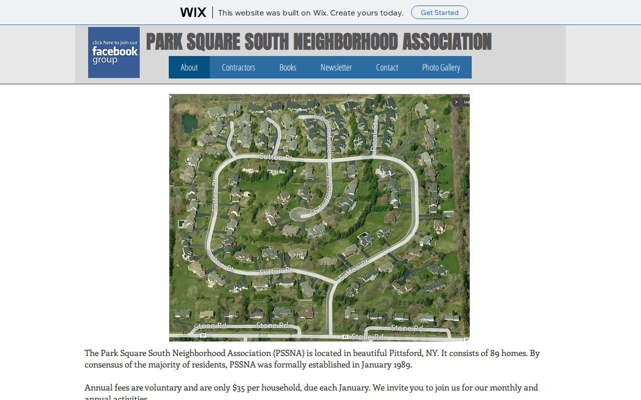
The screenshot illustrates the association's public-facing layer, not a resident list or an invitation to identify private members.
Park Square South
Public association description for a voluntary 89-home community group. Membership instructions are public; a member roster is not.
Wood Creek
Its public page says the resident directory, governing documents, financial information, and board minutes require resident login. Request access through the stated member process only.
Historical community clues
The 1937 Pittsford directory listed civic groups such as the fire organization, PTA, Grange, Scouts, and Legion as period evidence, not current neighborhood rosters.
Pittsford Rotary and the Women’s Club appear in current town newsletter context, while the Chamber member directory is a business resource rather than a household list. Rochester Public Library and the Town Historian are better paths for a dated community or street-history question.
Trace Pittsford Block Deeds
Once the map confirms an adjacent parcel, the recorded ownership trail belongs to that single lot. Search the Monroe County Clerk Official Records index with the parcel's address or a known recorded owner. Record the grantor, grantee, recording date, instrument type, legal description, and book/page or file number. Then use the seller as a prior grantee if the question concerns an earlier title transfer. Keep every chain in a separate note so one parcel's parties do not migrate to another lot.
The index reports records from February 15, 1954, and images beginning December 31, 1984. County guidance treats the 1970s to present as the practical online period. For earlier work, the Clerk's historical method uses a year and a grantee-surname initial in the index books, followed by the liber and page in deed books or microfilm. A deed explains a recorded transaction. It does not prove which people lived on the parcel at any later time.
Read Pittsford Block History
Historic street evidence can give a block a date without turning a modern map into a historical roster. Rochester Public Library has Pittsford directory entries for 1935 through 1940, plus a 1934 regional directory and an inspected 1937 volume. The 1937 entries can show a name, spouse in parentheses, occupation or business reference, street address, and an r renter mark. Its street guide also gives cross-street relationships for roads such as Reeves, San Rafael, Schoen Place, South, and Sutherland.
Start with the Rochester Public Library's digitized suburban directories, preserve the published spelling and number, and compare it with a plat, Sanborn map, or legal description. The Town, Village, and Rochester postal layers can differ, and older sources can use earlier road language. A dated directory entry supports a historical clue only. It should be checked against the parcel and deed trail before a block history is stated as fact.
Check Pittsford Block Records
The Monroe County voter lookup is an individual confirmation tool. Its visible inputs are street number, street name, ZIP Code, last name, and date of birth. A matching result can return registration information, polling place, sample ballot, absentee or mail-ballot status, and elected-official context. It does not publish a block-wide list, party-history view, or ballot choice. Use it only when enough matching information is already known.
| Official record route | Careful block use | What to avoid |
|---|---|---|
| GIS and assessment records | Locate adjacent parcels and distinguish tax geography from a mailing address | Calling every listed owner an occupant |
| Clerk deed index | Confirm recorded title parties and chronology one parcel at a time | Assuming a deed proves current residence |
| Voter lookup | Confirm one known person's registration context | Compiling a public block roster |
| Commercial neighbor-lookup category | Recognize it only as an unverified lead category | Relying on stale, merged, or purchased data as an authority |
New York Election Law §3-220 withholds driver-license, non-driver ID, Social Security, and facsimile numbers. State voter-file requests also require an elections purpose under Election Law §3-103(5). Ballot choices are not a public result in this workflow.
Pittsford Neighborhood Geography
Town of Pittsford, Village of Pittsford, Monroe County, postal city, ZIP Code, and tax parcel are separate layers. The official town map places the Village within the Town and also shows nearby Rochester, Brighton, Mendon, Perinton, and East Rochester. This matters on a block where the postal label may not match the governmental parcel jurisdiction. It also explains why a route, district, or street name needs a map and parcel check before it is treated as a neighborhood boundary.
Official town material uses both Pittsford 14534 and Rochester 14618 addresses in the town context. USPS should verify delivery geography for one address, while GIS and the tax parcel identify the relevant local jurisdiction. Historic directories add another layer: a 1930s entry can use an earlier road or house-number convention. Keep the original form beside the modern parcel reference rather than forcing them to match without a legal description, plat, or cross-street bridge.
Pittsford Neighbor Privacy Limits
Public parcel records do not disclose every household member, renter, utility customer, delivery recipient, or private association member. A recorded owner is not every occupant. A voter match is not a block roster. New York's Address Confidentiality Program uses a substitute address for qualifying participants, and the courts have confidential-address procedures. In those situations, an absent or inconsistent address may be a safety protection rather than a data problem.
Lawful use. Use Town of Pittsford neighbor records for careful personal research and civic context. Never use a parcel, map, directory, or association detail to stalk, harass, threaten, or repeatedly contact a person.
FOIL also allows privacy-based withholding or redaction where disclosure would be an unwarranted invasion of personal privacy. A focused request may seek existing segregable records, but it cannot require an office to create a new neighbor list or disclose protected information. Stop at the public boundary and verify significant facts with the responsible custodian.