
Trace Town of Pittsford Streets
A Town of Pittsford street search begins with the physical parcel, not a presumed household list. The Town Assessor directs parcel questions to Monroe County's real-property resources and can verify a specific parcel. Then use the Mapping Monroe parcel viewer to place that parcel among roads and touching lots. The final steps separate recorded ownership, registration confirmation for a known individual, and historic listing evidence. Each source answers a narrower question, which prevents a street directory search from turning an address clue into an unsupported claim about a household.
- Enter the known address with the assessor or property route and record the tax-map parcel number, property location, assessment, exemption code, and taxing jurisdictions shown on the roll.
- Find the same place in Mapping Monroe. Use the house-number or house-owner tools when available, select the parcel polygon, and note the surrounding street pattern.
- Search the Monroe County Clerk Official Records index by the address or recorded owner. Keep the document type, recording date, parties, legal description, and book/page or file number.
- Use the Monroe voter lookup only for a known person. Its street number, street name, ZIP, last name, and date-of-birth inputs confirm one registration context, not everyone on the street.
- For an older address, compare the result with the digitized Pittsford directory years at Rochester Public Library. A street guide and an annual name entry can bridge a changed address without claiming present occupancy.
Note: Record the search date and the parcel number before moving to another source, because names, mailing addresses, and online displays can change.
Pittsford Street Record Sources
The usable Town of Pittsford street directory sources are keyed to different identifiers. The assessment roll is tied to a tax parcel. GIS is tied to a mapped polygon. The Clerk index is tied to parties, documents, dates, legal descriptions, book/page references, and file numbers. A permit is tied to an address and project. A directory is a dated publication. Combining them is more reliable than treating any one source as a complete street roster.
| Address record | Custodian | Useful evidence | Access route |
|---|---|---|---|
| Assessment roll | Town Assessor and Monroe Real Property Services | Tax-map parcel, property location and class, assessment, exemption, Village, County, Town, and School columns | County property route, assessor verification, and published roll |
| Parcel viewer | Monroe GIS | Parcel shape, road setting, house-number or owner tools, identify/report links, and public layers | Public Mapping Monroe viewer |
| Recorded instruments | Monroe County Clerk | Grantor, grantee, date, document type, legal description, and document identifiers | Free index, office terminal, subscription image access, or copy request |
| Permit or certificate | Pittsford Code Enforcement / DPW | Construction, addition, deck, pool, sign, inspection, or compliance timing | Office request or a focused FOIL request |
| Directory street guide | Rochester Public Library | Dated name, address, renter mark, spouse, occupation, and street relationships | Digitized Pittsford volumes and Local History collections |
A primary-residence exemption can add context, but it remains an exemption on a tax parcel, not proof of every person at the address. Likewise, a deed documents a conveyance, not daily residence. For a historic name or listed occupant, the Town of Pittsford Directory Book has the fuller collection context and annual-directory reading conventions.
Map Pittsford Addresses by Parcel
Mapping Monroe is the local street-level geography layer. Its documented controls include house number, house owner, Identify Polygon, Layers, Basemap, Geolocate, Home, Clear, Reports, Print, Share, and Share Map. Search an address or owner, select the parcel, and use the map view to distinguish the target lot from nearby parcels. The exact layer list and report fields were not captured in the research, so the live viewer is the source for its current display.
| Viewer control | How it supports an address search |
|---|---|
| House number | Runs an address-keyed map search; street-name behavior was not fully exposed. |
| House owner | Provides an owner-name map-search tool in the viewer assets. |
| Identify Polygon | Selects a parcel and opens the related identify or report path. |
| Layers and Basemap | Add public map context while keeping the selected parcel in view. |
| Reports, Print, and Share | Preserve a dated map view or use a currently offered report option. |
Town maps also publish a street index, zoning, refuse districts, trails, and a residential-neighborhood zoning resource. Those layers describe public geography. They do not establish a private association, a complete household, or a person's current whereabouts.
Follow Deeds Along Pittsford Streets
The Clerk's index is the ownership-history link in a Town of Pittsford street directory search. Its modes include Name, Document Type, Book/Page, Clerk File Number, Record Date, Legal, and Quick Search. The visible name search provides Party Type, Name, Book Type, Document Type, Document Category, Begin Date, and End Date, plus date shortcuts. Start with a known address or owner, preserve the newest instrument's identifiers, then follow the seller as a prior grantee. For a full street, repeat the work parcel by parcel rather than assuming that a map creates an all-address result.
The Monroe Clerk index keeps index fields free. The Clerk announced that digital original documents require a subscription beginning April 1, 2026, while public terminals and written copy requests remain alternatives. That makes an index number, book/page, or file number the valuable first result. The index states a start date of February 15, 1954 and images beginning December 31, 1984; Clerk guidance treats the 1970s to present as the practical online era and sends earlier work to index books and microfilm.
The Monroe Clerk Official Records search shows the search modes used to identify a document before an image or copy is needed.
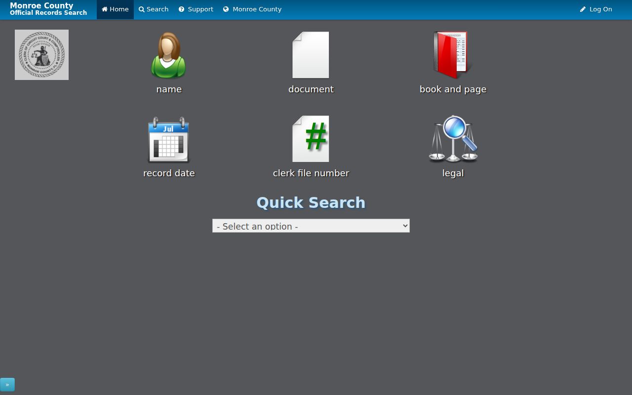
Use the document details to connect a parcel to a recorded transaction, then retain the legal description and tax-map number as separate identifiers for the next search.
Before 1975, the Clerk's historical guide directs researchers to the grantee index books by year and surname initial, followed by the listed liber and page in the deed book or microfilm. Assistance is available through the Clerk's land-record channels when an older instrument needs help locating.
Read Pittsford Street Address Clues
A Pittsford address needs more than one label. A situs address is the physical parcel location. A mailing address is where tax notices go and may be elsewhere. A legal description identifies the lot, subdivision, or metes-and-bounds language used in the deed. Postal geography adds another layer: official town material includes both Pittsford 14534 and Rochester 14618 addresses. A Rochester postal city does not by itself move a parcel outside the Town of Pittsford.
- Parcel or tax-map number
- The tax unit identifier used to connect the assessment roll, map, and related property work.
- Situs address
- The physical property location, distinct from the notice mailing address.
- Plat
- A map of a subdivision or lots that can bridge a street address to a legal description.
- Street or house section
- A directory arrangement that can connect a published address back to a listed name when an issue includes it.
The 1937 Pittsford directory is especially useful for an old street reference. It gives route relationships for roads including Reeves, San Rafael, Schoen Place, South, and Sutherland. Its entries can mark a renter with r, place a spouse in parentheses, and include an occupation or business reference. These are dated editorial clues, not a current resident roll. When a number is missing, use cross streets, a plat or Sanborn map, and the deed description before matching it to a modern parcel.
Note: Keep the original street spelling and abbreviation beside a normalized modern form until a parcel or legal-description bridge confirms the match.
Pittsford Permits by Address
Building permits, inspections, and certificates of occupancy or compliance can date work at a Town of Pittsford address. Pittsford Code Enforcement lists permits for construction, additions, decks, pools, signs, and related work. No public online permit or code-case search was located. The practical fallback is a narrow request to Code Enforcement or DPW, followed by a Town of Pittsford FOIL request that names the address, permit class, and approximate date range.
The FOIL process is for existing records, not a request that staff create a household list. Town guidance says it will contact a requester within five business days; readily available records should be provided within 20 days or less, otherwise an estimate is given. Standard black-and-white copies are listed at $0.25 per page. An applicant may be an owner, contractor, or another contact, so permit data should be read as project evidence rather than proof of occupancy.
Pittsford Voter Checks by Address
The Monroe voter tool can corroborate one known person's current registration setting after the parcel and address have been checked. Enter the street number, choose the street name, add the ZIP Code and last name, then use the date of birth in the stated format. The advertised result types are registration information, an Election Day polling place, a sample ballot, absentee or mail-ballot status, and elected-official context. Results should be compared with the exact address and the record date, because a move or a spelling difference can prevent a match.
This is not a way to browse a street. The public form does not expose every voter at an address or along a road, and it does not show ballot choices. Protected identifiers are withheld under Election Law §3-220. A full state voter-file request has a separate route and must state an elections purpose under Election Law §3-103(5). That boundary keeps a street-by-street search focused on a specific, lawful confirmation question.
Pittsford Street Geography Layers
Town of Pittsford, Village of Pittsford, Monroe County, postal city, ZIP Code, and tax parcel do not always use the same boundary. The official 2024 town map places the Village inside the Town and shows the nearby Rochester, Brighton, Mendon, Perinton, and East Rochester relationships. Use the street index and parcel map to determine which layer governs the record being read. A postal city alone is not enough for a tax or local-jurisdiction conclusion.
Older sources need the same care. Before standardized postal conventions, a directory might use a town, village, road, or house-number label that differs from the current display. Local historic material documents Northfield, Boyle, and Smallwood as earlier area names before the 1814 division. A legal description, lot or subdivision reference, cross street, and tax parcel are safer bridges than a guessed house-number conversion.
Pittsford Deed Index Alerts
The Clerk's index can also support an ownership-monitoring question. Monroe County's free property-fraud alert service lets a person set alerts for names or properties through the official Fraud Alert registration. It is a notice tool, not proof that a filing is improper and not a replacement for reading the recorded instrument. Keep a document identifier, recording date, and parcel reference when checking an alert against the Clerk index.
The April 2026 image-access change makes this two-stage approach useful: first locate the instrument in the free index, then decide whether an original image or certified copy is needed. A public terminal or written request remains available when digital images are gated. If a filing appears suspicious, verify it directly with the Clerk and preserve the instrument, book/page, date, and parcel number.
Pittsford Street Evidence Limits
A street directory can identify a parcel, a recorded owner, a historical directory listing, or a known voter's registration context. It cannot supply a reliable list of every resident. Renters and other household members are not collected in one public street roster. Utility and delivery data are not public substitutes. New York's Address Confidentiality Program can provide qualifying participants a substitute address, and courts may use confidential-address procedures. A missing match can reflect a move, an address variation, a protection, or a record that was never public.
Lawful use. Use Town of Pittsford address records for careful personal research. New York law prohibits stalking and harassment; never use parcel, deed, or directory material to pursue, intimidate, or repeatedly contact someone.
The individual voter lookup also has firm boundaries. It does not offer a public street-wide browse, and state voter-file requests require an elections purpose under Election Law §3-103(5). For one person with a known name and address, compare only the needed official records and respect redactions, access limits, and protected-address rules.